Scroll Down to Explore!
Scroll Down to Explore!
Scroll Down to Explore!
Scroll Down to Explore!
The Vision
The Capitol Mall Design Framework is a long term vision for the future of the Capitol Mall. It reflects five months of working with community partners, government agencies and Minnesotans from across the state. The framework ensures that each project done on the Capitol Mall over the coming years is leading toward a greater vision.
View Full Framework & Legend
A Reimagined Mall
The stakeholders and community worked together to reimagine a Capitol Mall that has increased shade and human comfort. The renovated Upper Mall connects people to their Capitol, preserves key site lines, activates the space year-round and grows a more resilient urban canopy.
Existing Conditions
The Capitol Area Architectural and Planning Board (CAAPB), with the help of Minnesotans, Saint Paul communities and local agencies, created a plan to better Connect, Preserve, Activate and Grow the Minnesota Capitol Mall. This process, called the Capitol Mall Design Framework which was adopted is attached to the 2040 Comprehensive Plan, relied on the input of Minnesotans from across the state. This website is your hub to learn about the project and understand the details that your input helped to shape.
Existing Conditions
The Capitol Mall Design Framework (CMDF) is a long term vision for the future of Saint Paul’s Capitol Mall led by the Capitol Area Architectural and Planning Board (CAAPB). It is the result of a planning process completed in 2024, which engaged community partners, government agencies, and Minnesotans from across the state to reimagine a Mall that suits their needs. It follows and reinforces the broader planning recommendations of the 2040 Comprehensive Plan for the Minnesota State Capitol Area.
Planning & Design Scales
The Proposed Capitol Mall Design Framework makes a Mall that is MORE WELCOMING FOR MORE MINNESOTANS. The Design Framework lays out a multi-phase implementation strategy and a series of design guideline recommendations to be used as a decision making tool moving forward.
Site Hydrology
The Santa Monica Airport has a relatively low flood risk compared to other surrounding areas to the east.
Flow to Santa Monica Bay
Flow to Ballona Creek
Flood Risk
low-high
On-site Today
A variety of different uses and building types occupy the site today. In addition to aviation uses, the site is home to retail, art, cultural, institutional, and office facilities.
Retail / Restaurant
Arts/Culture/Institutional
Aviation Use
Office
Scheduled to be Demolished
Other
Site Materials
The Santa Monica Airport is 80% covered by impervious surfaces which include buildings, concrete, runway, plazas, and paths.
Pervious Surface
20%
Lawn
Sports Field
Interim landscape
Semi-Pervious Surface
80%
Building
Concrete & Asphalt
Tarmac
Plaza & Pathways
Site Topography
With the exception of the steep bluff drop off on the west side, the site is characterized by a relatively gentle east to west slope, which enables a clear view of the bay from many points of the property.
0-3 degrees
3-5
5-8
8-15
15-33
>33


Capitol Mall Design Framework
A Reimagined Mall
Intent of the Project
Planning & Design Scales
Making the Mall More Welcoming
Capitol Mall Design Framework
A Reimagined Mall
Intent of the Project
Planning & Design Scales
Making the Mall More Welcoming
Capitol Mall Design Framework
A Reimagined Mall
Intent of the Project
Planning & Design Scales
Making the Mall More Welcoming
Framework Plan
Vision
Intent of the Project
Planning & Design Scales
Making the Mall More Welcoming
Framework Plan
Vision
Intent of the Project
Planning & Design Scales
Making the Mall More Welcoming
Framework Plan
Vision
Intent of the Project
Planning & Design Scales
Making the Mall More Welcoming
A Reimagined Mall
The stakeholders and community worked together to reimagine a Capitol Mall that has increased shade and human comfort. The renovated Upper Mall connects people to their Capitol, preserves key site lines, activates the space year-round and grows a more resilient urban canopy.
A Reimagined Mall
The stakeholders and community worked together to reimagine a Capitol Mall that has increased shade and human comfort. The renovated Upper Mall connects people to their Capitol, preserves key site lines, activates the space year-round and grows a more resilient urban canopy.
A Reimagined Mall
The stakeholders and community worked together to reimagine a Capitol Mall that has increased shade and human comfort. The renovated Upper Mall connects people to their Capitol, preserves key site lines, activates the space year-round and grows a more resilient urban canopy.
Existing Conditions
The Capitol Area Architectural and Planning Board (CAAPB), with the help of Minnesotans, Saint Paul communities and local agencies, created a plan to better Connect, Preserve, Activate and Grow the Minnesota Capitol Mall. This process, called the Capitol Mall Design Framework which was adopted is attached to the 2040 Comprehensive Plan, relied on the input of Minnesotans from across the state. This website is your hub to learn about the project and understand the details that your input helped to shape.
Existing Conditions
The Capitol Mall Design Framework (CMDF) is a long term vision for the future of Saint Paul’s Capitol Mall led by the Capitol Area Architectural and Planning Board (CAAPB). It is the result of a planning process completed in 2024, which engaged community partners, government agencies, and Minnesotans from across the state to reimagine a Mall that suits their needs. It follows and reinforces the broader planning recommendations of the 2040 Comprehensive Plan for the Minnesota State Capitol Area.
Planning & Design Scales
The Proposed Capitol Mall Design Framework makes a Mall that is MORE WELCOMING FOR MORE MINNESOTANS. The Design Framework lays out a multi-phase implementation strategy and a series of design guideline recommendations to be used as a decision making tool moving forward.
Planning & Design Scales
The Proposed Capitol Mall Design Framework makes a Mall that is MORE WELCOMING FOR MORE MINNESOTANS. The Design Framework lays out a multi-phase implementation strategy and a series of design guideline recommendations to be used as a decision making tool moving forward.
Planning & Design Scales
The Proposed Capitol Mall Design Framework makes a Mall that is MORE WELCOMING FOR MORE MINNESOTANS. The Design Framework lays out a multi-phase implementation strategy and a series of design guideline recommendations to be used as a decision making tool moving forward.
Learn More
Learn More
Vision
A Vision for Connections
Cass Gilbert Memorial Park & Capitol Area
The Capitol Mall Design Framework is a vision for the responsible use of limited resources to consistently strengthen the Capitol as the heart of Saint Paul and Minnesota for years to come. Visit the Capitol Area Architectural and Planning Board (CAAPB) website to see the progress on implementation of Phase 1.

Conceptual rendering of Cass Gilbert Memorial Park looking southwest towards the Capitol and Saint Paul’s Cathedral.
Vision
Resilience + Remembrance
Lower Mall
The Framework looked to Indigenous plant communities to develop ethnobotanic landscapes that integrate stormwater management and resilience into the Mall. The site is made legible through interpretation and a comprehensive wayfinding program that addresses concerns of safety, access and user orientation.

Conceptual rendering of the Commemorative Circle and ethnobotanic gardens looking east.
Vision
A Community Commons
Reverend Dr. Martin Luther King Jr. Boulevard
The community and CAAPB united around a shared street on Reverend Dr. Martin Luther King Jr. Boulevard as a catalytic project to create a multi-functional and welcoming community commons to the Capitol. This was identified as the #1 most important project.

Conceptual rendering of the Community Commons (Reverend Dr. Martin Luther King Jr. Boulevard) looking northeast.
Vision
A Place for Public Life
John Ireland Boulevard
The Cultural Landscape Report (CLR) placed heavy importance on maintaining critical viewsheds, of which John Ireland Boulevard is one. The newly reimagined space will continue to have visual and physical connections between the Capitol, the Saint Paul Cathedral and Minnesota History Center. It will become a space to host new and existing events under a double allée along a pedestrian promenade that will provide a continuous canopy of shade in summers. John Ireland Boulevard will be the platform for daily life.

Conceptual rendering of John Ireland Blvd looking northeast towards the Capitol building.
Vision
A Node of Vitality
University & Rice Mobility Hub
The mobility hub and a transformed Rice Street is a centerpiece of the 2040 Comprehensive Plan vision for the Capitol Area, one that will transform Rice Street back into a more comfortable shared corridor of commerce and community activity.

Conceptual rendering of the University and Rice Mobility Hub looking north along Rice Street.
Vision
A Vision for Connections
Cass Gilbert Memorial Park & Capitol Area
The Capitol Mall Design Framework is a vision for the responsible use of limited resources to consistently strengthen the Capitol as the heart of Saint Paul and Minnesota for years to come. Visit the Capitol Area Architectural and Planning Board (CAAPB) website to see the progress on implementation of Phase 1.
Conceptual rendering of Cass Gilbert Memorial Park looking southwest towards the Capitol and Saint Paul’s Cathedral.
Vision
Resilience + Remembrance
Lower Mall
The Framework looked to Indigenous plant communities to develop ethnobotanic landscapes that integrate stormwater management and resilience into the Mall. The site is made legible through interpretation and a comprehensive wayfinding program that addresses concerns of safety, access and user orientation.
Conceptual rendering of the Commemorative Circle and ethnobotanic gardens looking east.
Vision
A Community Commons
Reverend Dr. Martin Luther King Jr. Boulevard
The community and CAAPB united around a shared street on Reverend Dr. Martin Luther King Jr. Boulevard as a catalytic project to create a multi-functional and welcoming community commons to the Capitol. This was identified as the #1 most important project.
Conceptual rendering of the Community Commons (Reverend Dr. Martin Luther King Jr. Boulevard) looking northeast.
Vision
A Place for Public Life
John Ireland Boulevard
The Cultural Landscape Report (CLR) placed heavy importance on maintaining critical viewsheds, of which John Ireland Boulevard is one. The newly reimagined space will continue to have visual and physical connections between the Capitol, the Saint Paul Cathedral and Minnesota History Center. It will become a space to host new and existing events under a double allée along a pedestrian promenade that will provide a continuous canopy of shade in summers. John Ireland Boulevard will be the platform for daily life.
Conceptual rendering of John Ireland Blvd looking northeast towards the Capitol building.
Vision
A Node of Vitality
University & Rice Mobility Hub
The mobility hub and a transformed Rice Street is a centerpiece of the 2040 Comprehensive Plan vision for the Capitol Area, one that will transform Rice Street back into a more comfortable shared corridor of commerce and community activity.
Conceptual rendering of the University and Rice Mobility Hub looking north along Rice Street.
Vision
A Vision for Connections
Cass Gilbert Memorial Park & Capitol Area
The Capitol Mall Design Framework is a vision for the responsible use of limited resources to consistently strengthen the Capitol as the heart of Saint Paul and Minnesota for years to come. Visit the Capitol Area Architectural and Planning Board website to see the progress on implementation of Phase 1.
Conceptual rendering of Cass Gilbert Memorial Park looking southwest towards the Capitol and Saint Paul’s Cathedral.
Vision
Resilience + Remembrance
Lower Mall
The Framework looked to Indigenous plant communities to develop ethnobotanic landscapes that integrate stormwater management and resilience into the Mall. The site is made legible through interpretation and a comprehensive wayfinding program that addresses concerns of safety, access and user orientation.
Conceptual rendering of the Commemorative Circle and ethnobotanic gardens looking east.
Vision
A Community Commons
Reverend Dr. Martin Luther King Jr. Boulevard
The community and CAAPB united around a shared street on Reverend Dr. Martin Luther King Jr. Boulevard as a catalytic project to create a multi-functional and welcoming community commons to the Capitol. This was identified as the #1 most important project.
Conceptual rendering of the Community Commons (Reverend Dr. Martin Luther King Jr. Boulevard) looking northeast.
Vision
A Place for Public Life
John Ireland Boulevard
The Cultural Landscape Report (CLR) placed heavy importance on maintaining critical viewsheds, of which John Ireland Boulevard is one. The newly reimagined space will continue to have visual and physical connections between the Capitol, the Saint Paul Cathedral and Minnesota History Center. It will become a space to host new and existing events under a double allée along a pedestrian promenade that will provide a continuous canopy of shade in summers. John Ireland Boulevard will be the platform for daily life.
Conceptual rendering of John Ireland Blvd looking northeast towards the Capitol building.
Vision
A Node of Vitality
University & Rice Mobility Hub
The mobility hub and a transformed Rice Street is a centerpiece of the 2040 Comprehensive Plan vision for the Capitol Area, one that will transform Rice Street back into a more comfortable shared corridor of commerce and community activity.
Conceptual rendering of the University and Rice Mobility Hub looking north along Rice Street.
Vision
A Vision for Connections
Conceptual rendering of Cass Gilbert Memorial Park looking southwest towards the Capitol and Saint Paul’s Cathedral.
Cass Gilbert Memorial Park & Capitol Area
The Capitol Mall Design Framework is a vision for the responsible use of limited resources to consistently strengthen the Capitol as the heart of Saint Paul and Minnesota for years to come. Visit the Capitol Area Architectural and Planning Board website to see the progress on implementation of Phase 1.
Vision
Resilience + Remembrance
Conceptual rendering of the Commemorative Circle and ethnobotanic gardens looking east.
Lower Mall
The Framework looked to Indigenous plant communities to develop ethnobotanic landscapes that integrate stormwater management and resilience into the Mall. The site is made legible through interpretation and a comprehensive wayfinding program that addresses concerns of safety, access and user orientation.
Vision
A Community Commons
Conceptual rendering of the Community Commons (Reverend Dr. Martin Luther King Jr. Boulevard) looking northeast.
Reverend Dr. Martin Luther King Jr. Boulevard
The community and CAAPB united around a shared street on Reverend Dr. Martin Luther King Jr. Boulevard as a catalytic project to create a multi-functional and welcoming community commons to the Capitol. This was identified as the #1 most important project.
Vision
A Place for Public Life
Conceptual rendering of John Ireland Blvd looking northeast towards the Capitol building.
John Ireland Boulevard
The Cultural Landscape Report (CLR) placed heavy importance on maintaining critical viewsheds, of which John Ireland Boulevard is one. The newly reimagined space will continue to have visual and physical connections between the Capitol, the Saint Paul Cathedral and Minnesota History Center. It will become a space to host new and existing events under a double allée along a pedestrian promenade that will provide a continuous canopy of shade in summers. John Ireland Boulevard will be the platform for daily life.
Vision
A Node of Vitality
Conceptual rendering of the University and Rice Mobility Hub looking north along Rice Street.
University & Rice Mobility Hub
The mobility hub and a transformed Rice Street is a centerpiece of the 2040 Comprehensive Plan vision for the Capitol Area, one that will transform Rice Street back into a more comfortable shared corridor of commerce and community activity.
Vision
A Vision for Connections
Conceptual rendering of Cass Gilbert Memorial Park looking southwest towards the Capitol and Saint Paul’s Cathedral.
Cass Gilbert Memorial Park & Capitol Area
The Capitol Mall Design Framework is a vision for the responsible use of limited resources to consistently strengthen the Capitol as the heart of Saint Paul and Minnesota for years to come. Visit the Capitol Area Architectural and Planning Board website to see the progress on implementation of Phase 1.
Vision
Resilience + Remembrance
Conceptual rendering of the Commemorative Circle and ethnobotanic gardens looking east.
Lower Mall
The Framework looked to Indigenous plant communities to develop ethnobotanic landscapes that integrate stormwater management and resilience into the Mall. The site is made legible through interpretation and a comprehensive wayfinding program that addresses concerns of safety, access and user orientation.
Vision
A Community Commons
Conceptual rendering of the Community Commons (Reverend Dr. Martin Luther King Jr. Boulevard) looking northeast.
Reverend Dr. Martin Luther King Jr. Boulevard
The community and CAAPB united around a shared street on Reverend Dr. Martin Luther King Jr. Boulevard as a catalytic project to create a multi-functional and welcoming community commons to the Capitol. This was identified as the #1 most important project.
Vision
A Place for Public Life
Conceptual rendering of John Ireland Blvd looking northeast towards the Capitol building.
John Ireland Boulevard
The Cultural Landscape Report (CLR) placed heavy importance on maintaining critical viewsheds, of which John Ireland Boulevard is one. The newly reimagined space will continue to have visual and physical connections between the Capitol, the Saint Paul Cathedral and Minnesota History Center. It will become a space to host new and existing events under a double allée along a pedestrian promenade that will provide a continuous canopy of shade in summers. John Ireland Boulevard will be the platform for daily life.
Vision
A Node of Vitality
Conceptual rendering of the University and Rice Mobility Hub looking north along Rice Street.
University & Rice Mobility Hub
The mobility hub and a transformed Rice Street is a centerpiece of the 2040 Comprehensive Plan vision for the Capitol Area, one that will transform Rice Street back into a more comfortable shared corridor of commerce and community activity.
Honoring the Past
Honoring the Past
Honoring the Past
Honoring the Past
The Capitol Mall Design Framework was guided by the Cultural Landscape Report to preserve the integrity of landscape character and sense of place as a forecourt to the Saint Paul Capitol Building; as a civic space available to all residents; as a place to practice First Amendment Rights; and as a landscape which is evolving with climate change.
The Capitol Mall Design Framework was guided by the Cultural Landscape Report to preserve the integrity of landscape character and sense of place as a forecourt to the Saint Paul Capitol Building; as a civic space available to all residents; as a place to practice First Amendment Rights; and as a landscape which is evolving with climate change.
The Capitol Mall Design Framework was guided by the Cultural Landscape Report to preserve the integrity of landscape character and sense of place as a forecourt to the Saint Paul Capitol Building; as a civic space available to all residents; as a place to practice First Amendment Rights; and as a landscape which is evolving with climate change.
The Capitol Mall Design Framework was guided by the Cultural Landscape Report to preserve the integrity of landscape character and sense of place as a forecourt to the Saint Paul Capitol Building; as a civic space available to all residents; as a place to practice First Amendment Rights; and as a landscape which is evolving with climate change.

1931 Minnesota Capitol Mall Plan by Cass Gilbert,
Source: https://cassgilbertsociety.org/works/mn-capitol/mn-capitol-axis/

1944 Nichols Plan,
Source: Minnesota Historic Society, 2024
Vision for the Community Commons
Learn More
Learn More
Learn More
Comprehensive Planning (2020-2021)
Comprehensive Planning (2020-2021)
Comprehensive Planning (2020-2021)
Vision: At the symbolic heart of the State, the vision for the Capitol Area is to be a unifying factor for all those who come to live, work, learn and play.
Vision: At the symbolic heart of the State, the vision for the Capitol Area is to be a unifying factor for all those who come to live, work, learn and play.
Vision: At the symbolic heart of the State, the vision for the Capitol Area is to be a unifying factor for all those who come to live, work, learn and play.
In June 2021 the CAAPB published the 2040 Comprehensive Plan for the Minnesota State Capitol Area. The plan envisions the Capitol Area through 2040 and defines how the district will relate to its surrounding context and support its diverse community. The plan outlines seven Capitol Area Principles for the future:
In June 2021 the CAAPB published the 2040 Comprehensive Plan for the Minnesota State Capitol Area. The plan envisions the Capitol Area through 2040 and defines how the district will relate to its surrounding context and support its diverse community. The plan outlines seven Capitol Area Principles for the future:
In June 2021 the CAAPB published the 2040 Comprehensive Plan for the Minnesota State Capitol Area. The plan envisions the Capitol Area through 2040 and defines how the district will relate to its surrounding context and support its diverse community. The plan outlines seven Capitol Area Principles for the future:
Destination
01
Focal
Point
02
Model for
Minnesota
03
Public
Realm
04
Seamlessly
Connected
05
Land Use
Diversity
06
Coordinated
07
Destination
01
Focal
Point
02
Model for
Minnesota
03
Public
Realm
04
Seamlessly
Connected
05
Land Use
Diversity
06
Coordinated
07
Destination
01
Focal Point
02
Model for Minnesota
03
Public Realm
04
Seamlessly Connected
05
Land Use Diversity
06
Coordinated
07
Destination
01
Focal Point
02
Model for Minnesota
03
Public Realm
04
Seamlessly Connected
05
Land Use Diversity
06
Coordinated
07
Process
Process
Process
Process
Approach
Approach
Approach
Approach
The Capitol Mall Design Framework is the result of a planning process, completed in 2024, which engaged community partners, government agencies and Minnesotans from across the state to reimagine a Mall that suits their needs. It follows and reinforces past planning work. Through collaboration with the Focus Groups, three themes emerged: Vitality, Diversity and Inclusivity. Those led to Eight Bold Design Moves - specific proposals to improve the Capitol Mall experience.
The Capitol Mall Design Framework is the result of a planning process, completed in 2024, which engaged community partners, government agencies and Minnesotans from across the state to reimagine a Mall that suits their needs. It follows and reinforces past planning work. Through collaboration with the Focus Groups, three themes emerged: Vitality, Diversity and Inclusivity. Those led to Eight Bold Design Moves - specific proposals to improve the Capitol Mall experience.
The Capitol Mall Design Framework is the result of a planning process, completed in 2024, which engaged community partners, government agencies and Minnesotans from across the state to reimagine a Mall that suits their needs. It follows and reinforces past planning work. Through collaboration with the Focus Groups, three themes emerged: Vitality, Diversity and Inclusivity. Those led to Eight Bold Design Moves - specific proposals to improve the Capitol Mall experience.

The Capitol Area Principles
The Capitol Area Principles
• Planning Principles • Analysis Lenses • Framework Themes • Eight Bold Design Moves
More Details
The Capitol Area Principles
The Capitol Area Principles
• Planning Principles • Analysis Lenses • Framework Themes • Eight Bold Design Moves
More Details
Analysis
Analysis
Analysis
Analysis
The Design Framework builds upon the 2040 Comprehensive Plan to shape, guide, and manage the Capitol Campus environment and its physical form. The Vision and Capitol Area Principles inform and guide every step of the Design Framework, most notably the analysis lenses that form the foundation for all design decisions moving forward. These analysis lenses include Connect, Preserve, Activate, and Grow.
The Design Framework builds upon the 2040 Comprehensive Plan to shape, guide, and manage the Capitol Campus environment and its physical form. The Vision and Capitol Area Principles inform and guide every step of the Design Framework, most notably the analysis lenses that form the foundation for all design decisions moving forward. These analysis lenses include Connect, Preserve, Activate, and Grow.
The Design Framework builds upon the 2040 Comprehensive Plan to shape, guide, and manage the Capitol Campus environment and its physical form. The Vision and Capitol Area Principles inform and guide every step of the Design Framework, most notably the analysis lenses that form the foundation for all design decisions moving forward. These analysis lenses include Connect, Preserve, Activate, and Grow.
The Design Framework builds upon the 2040 Comprehensive Plan to shape, guide, and manage the Capitol Campus environment and its physical form. The Vision and Capitol Area Principles inform and guide every step of the Design Framework, most notably the analysis lenses that form the foundation for all design decisions moving forward. These analysis lenses include Connect, Preserve, Activate, and Grow.

The 'Connect' Lens
The 'Connect' Lens
• City Connectivity • Campus Connectivity • Thresholds to the Capitol Campus • Capitol Campus Parking • Area Street Hierarchy • Streetscape Experience • Utilities & Infrastructure
More Details
The 'Connect' Lens
The 'Connect' Lens
• City Connectivity • Campus Connectivity • Thresholds to the Capitol Campus • Capitol Campus Parking • Area Street Hierarchy • Streetscape Experience • Utilities & Infrastructure
More Details
The 'Preserve' Lens
The 'Preserve' Lens
• Historically Diverse Communities • Capitol Area through Time • Campus Timeline • 2022 Historic Context Report • Viewshed Analysis • Sculptures, Monuments & Memorials
More Details
The 'Preserve' Lens
The 'Preserve' Lens
• Historically Diverse Communities • Capitol Area through Time • Campus Timeline • 2022 Historic Context Report • Viewshed Analysis • Sculptures, Monuments & Memorials
More Details

The 'Activate' Lens
The 'Activate' Lens
• Citywide Recreation • Neighborhood Demographics • Capitol Area Amenities • Capitol Mall Programing • Slope & Future Programming • Security & Public Assembly • Security Typologies
More Details
The 'Activate' Lens
The 'Activate' Lens
• Citywide Recreation • Neighborhood Demographics • Capitol Area Amenities • Capitol Mall Programing • Slope & Future Programming • Security & Public Assembly • Security Typologies
More Details

The 'Grow' Lens
The 'Grow' Lens
• Minnesota’s Ecosystems • Mississippi Flyway • Ecosystem Heritage • Landscape Typologies • Capitol Area Tree Canopy • Thermal Comfort • Stormwater Systems
More Details
The 'Grow' Lens
The 'Grow' Lens
• Minnesota’s Ecosystems • Mississippi Flyway • Ecosystem Heritage • Landscape Typologies • Capitol Area Tree Canopy • Thermal Comfort • Stormwater Systems
More Details
8 Bold Design Moves
8 Bold Design Moves
8 Bold Design Moves
The eight bold design moves were born out of extensive community and stakeholder engagement. They collectively make up the culminating Capitol Mall Design Framework.
The eight bold design moves were born out of extensive community and stakeholder engagement. They collectively make up the culminating Capitol Mall Design Framework.
The eight bold design moves were born out of extensive community and stakeholder engagement. They collectively make up the culminating Capitol Mall Design Framework.

Enhance User Experience
Enhance User Experience
Enhance the visitor experience and make for a more inclusive and welcoming space.
More Details
Enhance User Experience
Enhance User Experience
Enhance the visitor experience and make for a more inclusive and welcoming space.
More Details

Reinvigorate Nodes
Reinvigorate Nodes
Invest in six key nodes within the Capitol Area to become destinations with a vibrant public realm for residents and visitors alike.
More Details
Reinvigorate Nodes
Reinvigorate Nodes
Invest in six key nodes within the Capitol Area to become destinations with a vibrant public realm for residents and visitors alike.
More Details

Right-size the Roads
Right-size the Roads
Increase the quality and quantity of space dedicated to pedestrians, street trees, and green infrastructure.
More Details
Right-size the Roads
Right-size the Roads
Increase the quality and quantity of space dedicated to pedestrians, street trees, and green infrastructure.
More Details
Sculpt Topography
Sculpt Topography
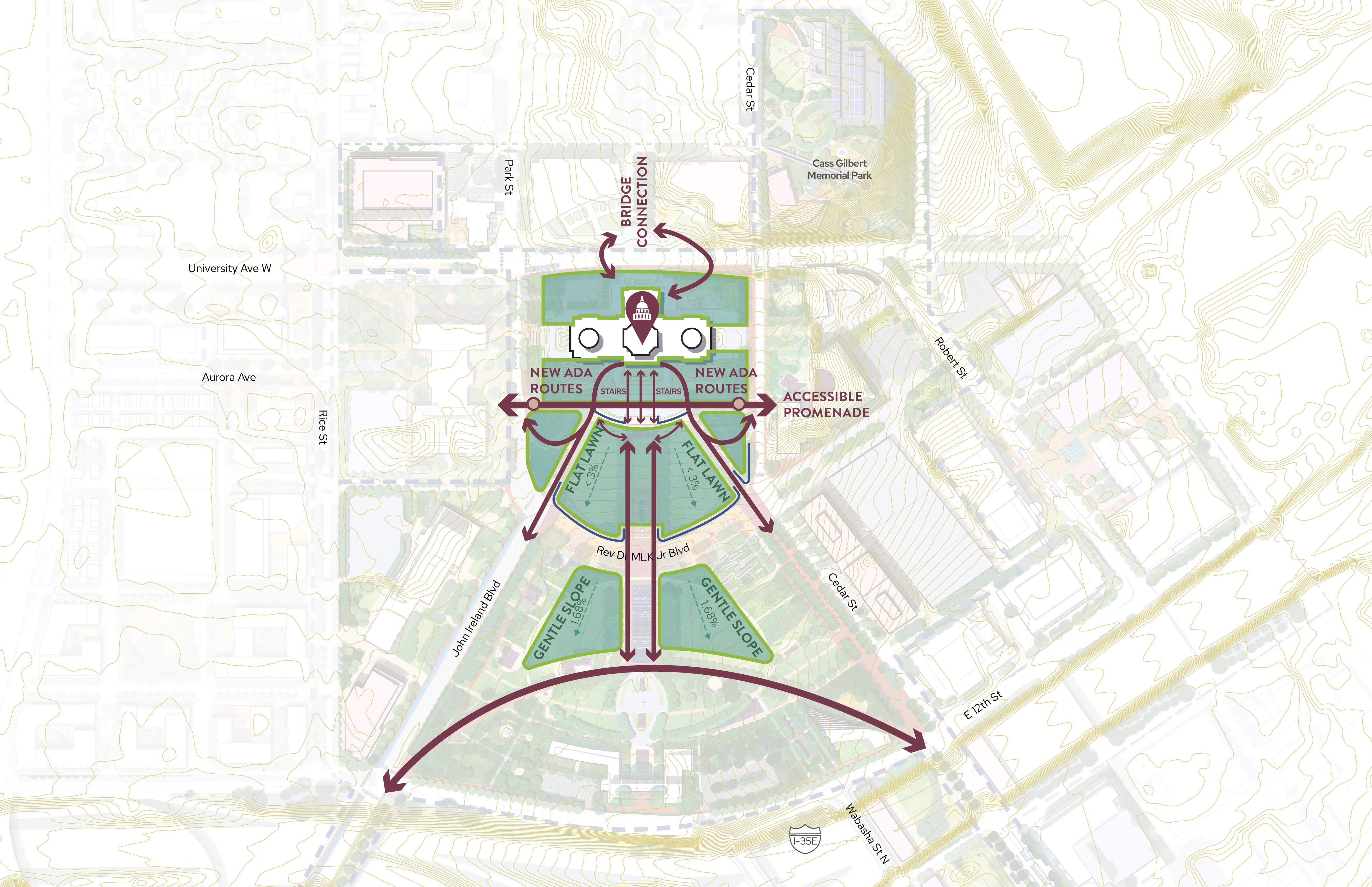
Enable people of all abilities to circulate through the site while emphasizing historic design values and security.
More Details
Sculpt Topography
Sculpt Topography
Enable people of all abilities to circulate through the site while emphasizing historic design values and security.
More Details

New Public Space Strategies
New Public Space Strategies
Connect to the community and develop spaces for events and flexible programming.
More Details
New Public Space Strategies
New Public Space Strategies
Connect to the community and develop spaces for events and flexible programming.
More Details

Celebrate Water
Celebrate Water
Approach stormwater management at the District level and site scale through a variety of interventions in the rights of way and open space.
More Details
Celebrate Water
Celebrate Water
Approach stormwater management at the District level and site scale through a variety of interventions in the rights of way and open space.
More Details
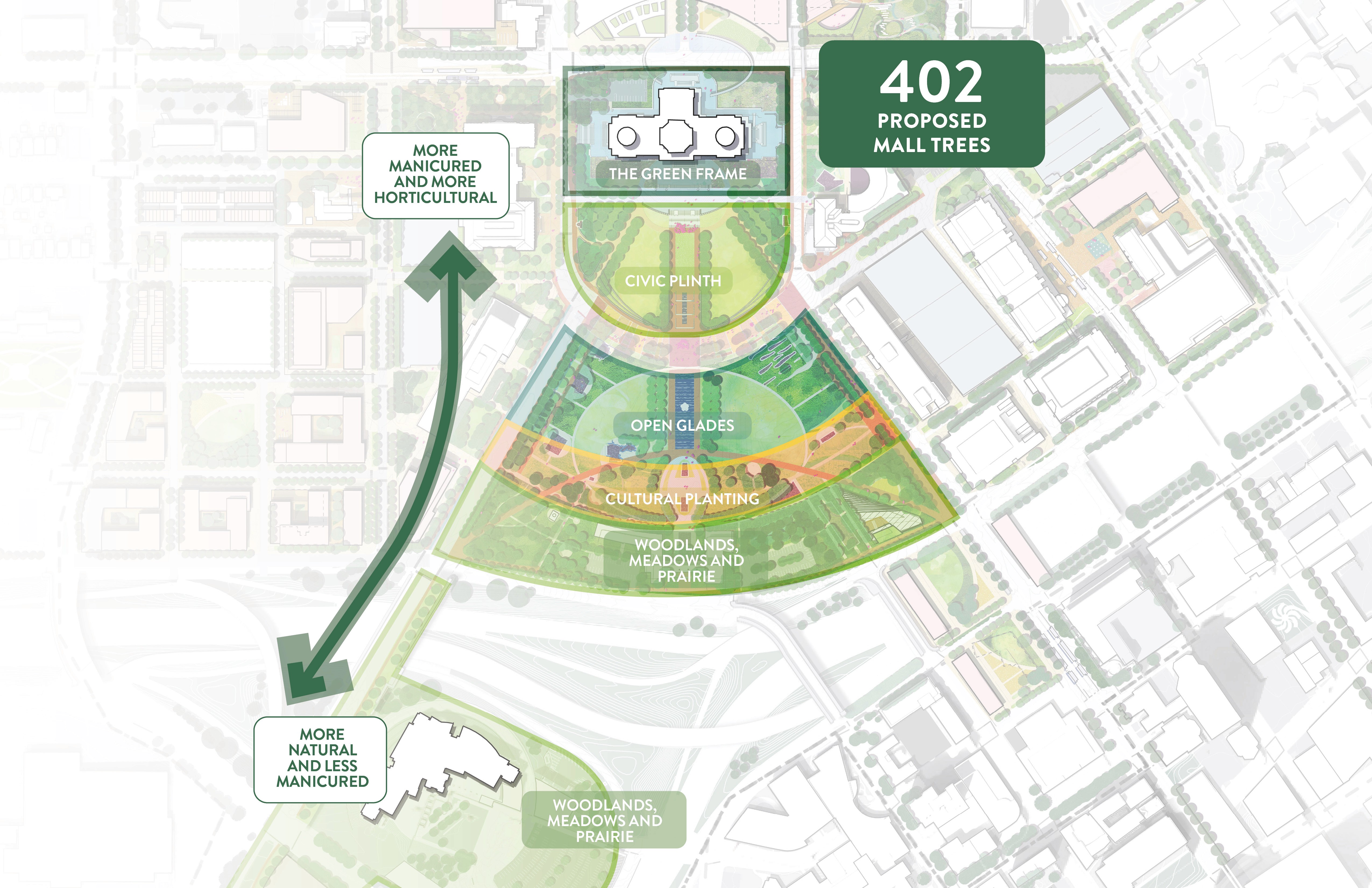
Create a Gradient of Planting Strategies
Create a Gradient of Planting Strategies
Craft planting strategies that reflect the diverse ecologies of Minnesota.
More Details
Create a Gradient of Planting Strategies
Create a Gradient of Planting Strategies
Craft planting strategies that reflect the diverse ecologies of Minnesota.
More Details

Transform Cass Gilbert Park
Transform Cass Gilbert Park
Reimagine Cass Gilbert Memorial Park as a public space for the wider community with play, nature, and gathering spaces.
More Details
Transform Cass Gilbert Park
Transform Cass Gilbert Park
Reimagine Cass Gilbert Memorial Park as a public space for the wider community with play, nature, and gathering spaces.
More Details
Engagement
Engagement
Engagement
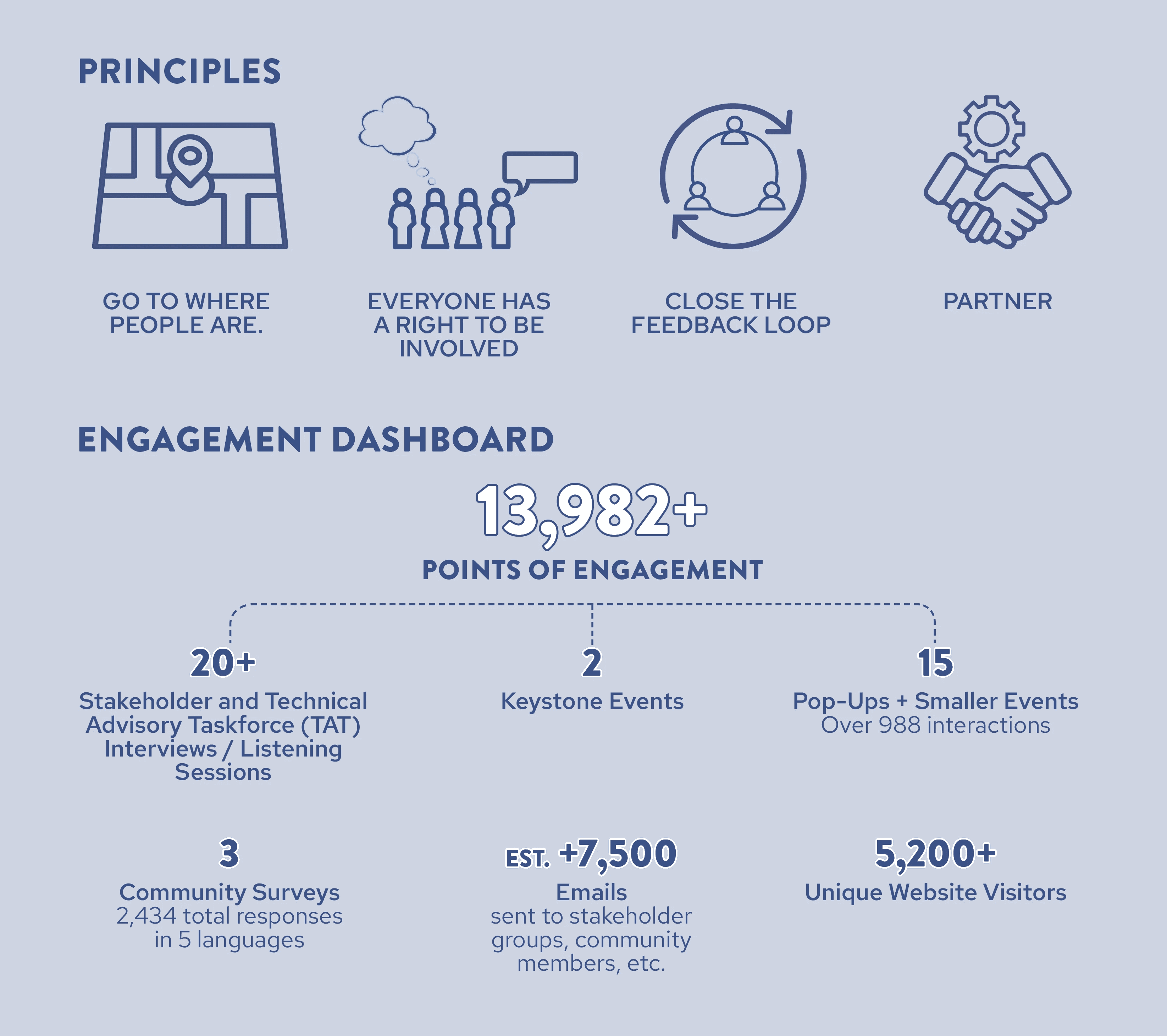
The engagement approach plans and executes a comprehensive process focused on rigorous site analysis and robust stakeholder and community engagement. It also identifies feasible and phaseable design strategies and implementation steps.
The engagement approach plans and executes a comprehensive process focused on rigorous site analysis and robust stakeholder and community engagement. It also identifies feasible and phaseable design strategies and implementation steps.
The engagement approach plans and executes a comprehensive process focused on rigorous site analysis and robust stakeholder and community engagement. It also identifies feasible and phaseable design strategies and implementation steps.
Click image to open downloadable PDF
Engagement
Engagement events varied throughout the process tailored to different audiences of community stakeholders, State and City agencies and elected officials. Through a series of listening sessions, interactive workshops, and online surveys, a large cross section of Minnesotans were given an opportunity to be part of the development of the CMDF at every step of the way. Key to the success of the Framework Plan was the four day collaborative charrette that set the direction for the project.


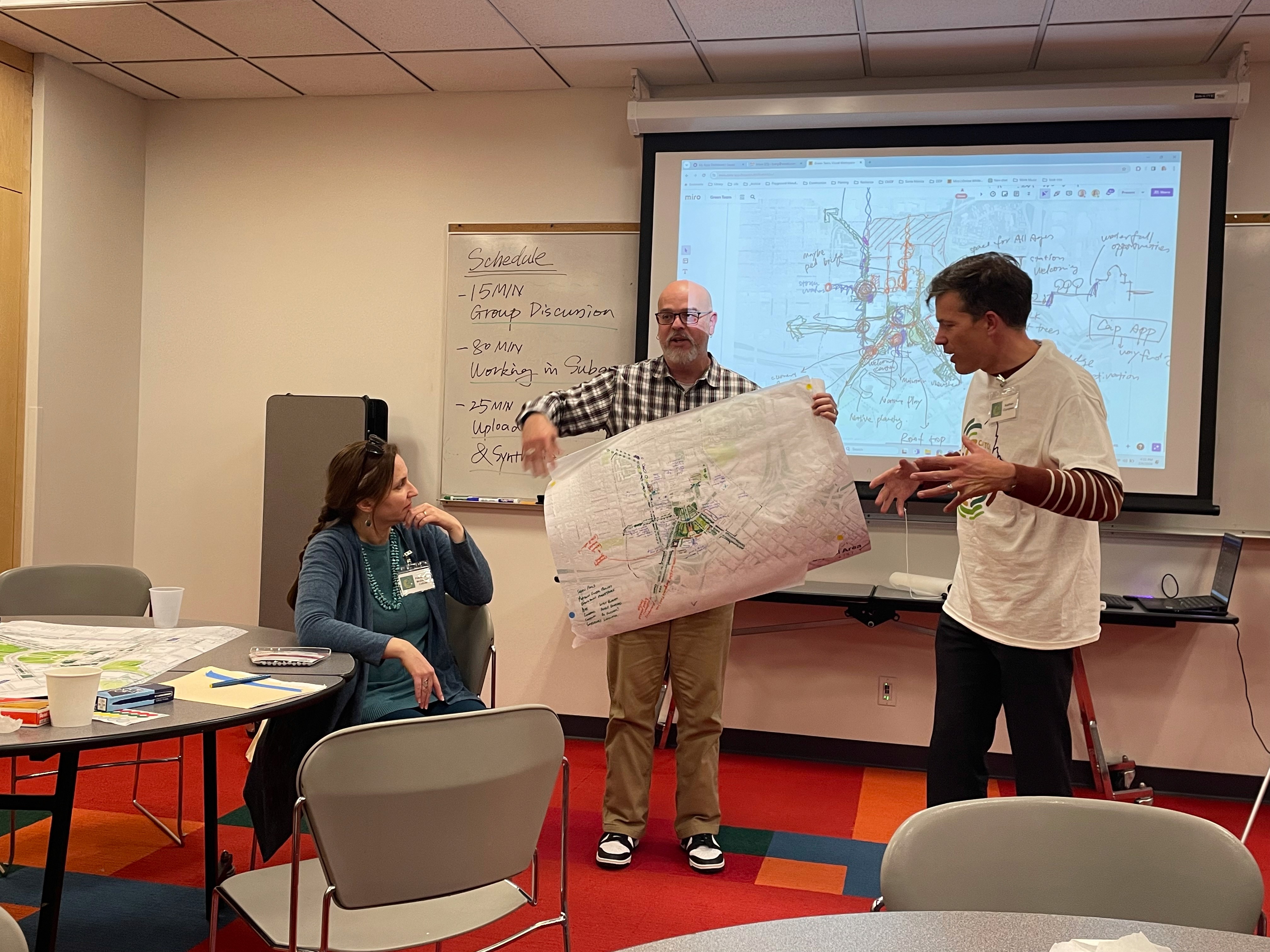
Community Design Charrette
In January and February of 2024, the CMDF planning team went into the community in a series of pop-ups to learn what Minnesotans want to see for the future of the Capitol Mall and its surrounding public spaces. We had inspiring conversations across the Twin Cities at Hmongtown Marketplace, Frogtown Community Center, Saint Paul Winter Carnival, and Midtown Global Market.


Pop Ups
From February 5 through 8 of 2024, representatives of community organizations, local business, government agencies and Capitol Area neighbors gathered with the planning team to develop a vision for the future of the Capitol Mall. This event took ideas gathered through research, community surveys and the lived experiences of participants and forged them together into an emerging design framework.


Engagement
Engagement events varied throughout the process tailored to different audiences of community stakeholders, State and City agencies and elected officials. Through a series of listening sessions, interactive workshops, and online surveys, a large cross section of Minnesotans were given an opportunity to be part of the development of the CMDF at every step of the way. Key to the success of the Framework Plan was the four day collaborative charrette that set the direction for the project.
Community Design Charrette
In January and February of 2024, the CMDF planning team went into the community in a series of pop-ups to learn what Minnesotans want to see for the future of the Capitol Mall and its surrounding public spaces. We had inspiring conversations across the Twin Cities at Hmongtown Marketplace, Frogtown Community Center, Saint Paul Winter Carnival, and Midtown Global Market.
Pop Ups
From February 5 through 8 of 2024, representatives of community organizations, local business, government agencies and Capitol Area neighbors gathered with the planning team to develop a vision for the future of the Capitol Mall. This event took ideas gathered through research, community surveys and the lived experiences of participants and forged them together into an emerging design framework.
A Node of Vitality
Engagement
Engagement events varied throughout the process tailored to different audiences of community stakeholders, State and City agencies and elected officials. Through a series of listening sessions, interactive workshops, and online surveys, a large cross section of Minnesotans were given an opportunity to be part of the development of the CMDF at every step of the way. Key to the success of the Framework Plan was the four day collaborative charrette that set the direction for the project.
A Node of Vitality
Community Design Charrette
In January and February of 2024, the CMDF planning team went into the community in a series of pop-ups to learn what Minnesotans want to see for the future of the Capitol Mall and its surrounding public spaces. We had inspiring conversations across the Twin Cities at Hmongtown Marketplace, Frogtown Community Center, Saint Paul Winter Carnival, and Midtown Global Market.
A Node of Vitality
Pop Ups
From February 5 through 8 of 2024, representatives of community organizations, local business, government agencies and Capitol Area neighbors gathered with the planning team to develop a vision for the future of the Capitol Mall. This event took ideas gathered through research, community surveys and the lived experiences of participants and forged them together into an emerging design framework.
Planning & Design Resources
Planning & Design Resources
Planning & Design Resources


Engagement Resources
Engagement Resources
Engagement Resources

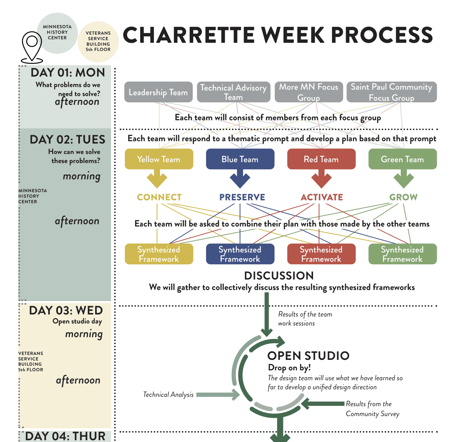


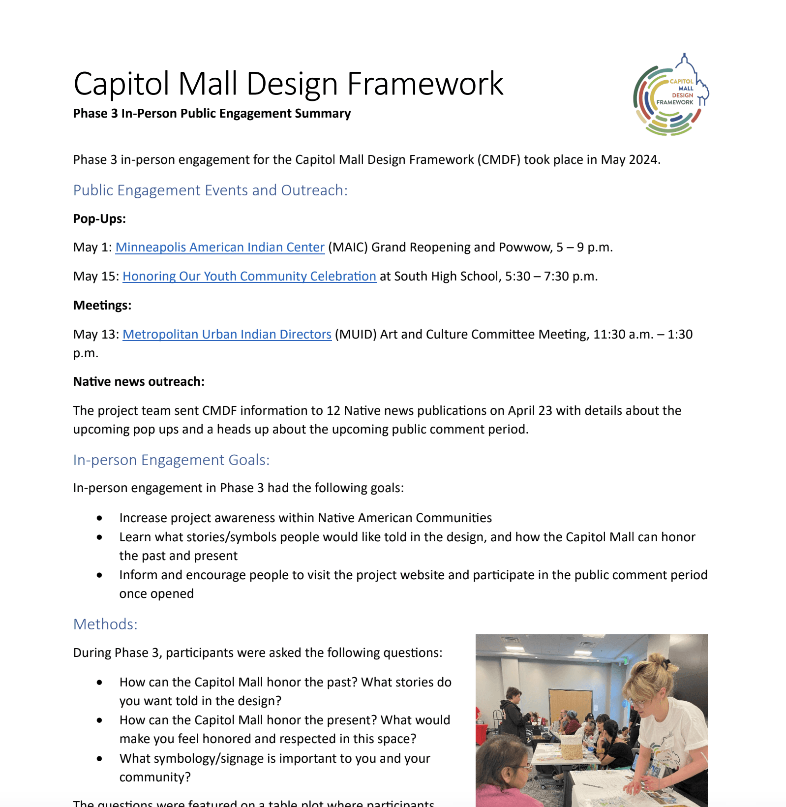
CMDF Statewide Community Open House
CMDF Statewide Community Open House
CMDF Statewide Community Open House


Meet the Team
Meet the Team
Meet the Team